
Hurricanes explained: how do hurricanes form, why they spin and what the eye is
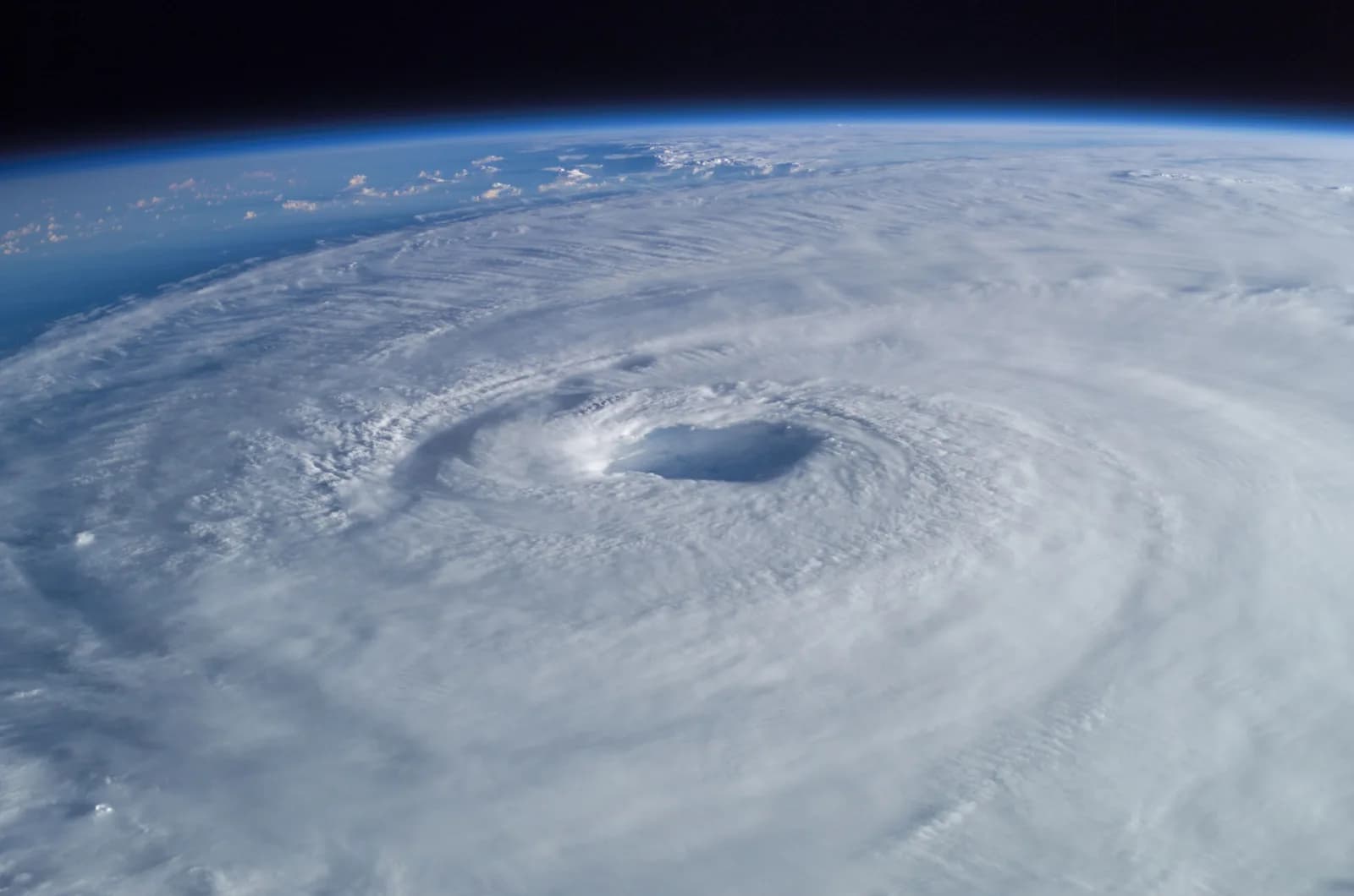
A hurricane forms when a cluster of thunderstorms sits over sea water of at least about 27 °C (80 °F): warm, moist air rises, its vapour condenses, and the heat released pulls in more air from below. Earth’s rotation bends that inflow into a spiral, and once sustained winds reach 119 km/h (74 mph) the storm is a hurricane, with a calm eye usually 30 to 65 km wide at its centre.
People who ask how do hurricanes form usually want a plain chain of cause and effect. It is short: warm sea, rising air, spin, then a storm that feeds itself. This guide follows the steps in order, gives the five categories with their wind speeds, and explains why most disturbances never get that far. Reading time is about five minutes.
Key ideas
- A hurricane needs warm ocean water (at least about 27 °C), moist unstable air, an existing cluster of thunderstorms and little change of wind with height.
- The engine is heat: when sea vapour condenses into cloud, the heat released makes the air rise faster and draws more air in at the surface.
- Earth’s rotation (the Coriolis effect) turns the inflow into a spiral, anticlockwise in the Northern Hemisphere and clockwise in the Southern, so storms do not form right on the equator.
- A storm becomes a hurricane at sustained winds of 119 km/h (74 mph); the Saffir-Simpson scale has five categories, and category 5 starts at 252 km/h (157 mph).
- Over land or cold water the fuel is cut and a hurricane weakens in a day or two, but storm surge and flooding rain stay dangerous.
The short answer: a heat engine run by warm sea water
Think of a hurricane as an engine whose fuel is the warm sea. NOAA gives the minimum water temperature as about 27 °C (80 °F), and the warm layer needs to be deep, about 50 metres, so that the storm’s own wind cannot stir up cold water from below and switch the engine off. Water evaporates from that sea and the moist air rises.
High up the vapour cools and condenses into cloud, and condensing releases heat. The heat warms the surrounding air, so it rises even faster, and air at the surface rushes in to take its place. On the way in that air picks up more vapour from the sea, and the loop feeds itself. A hurricane therefore runs less on warm air than on the heat that vapour carries out of the ocean.
Heat is only the fuel. NOAA lists the other conditions: a disturbance to start from, such as a tropical wave or a group of thunderstorms; an unstable atmosphere with moist air at middle heights; a position at least about 300 km (200 miles) from the equator; and low vertical wind shear, which means that wind speed and direction change little with height. Strong shear tears the top off a young storm.
Step by step: from thunderstorms to a hurricane
Many Atlantic storms start as a tropical wave, a ripple of thunderstorms that leaves the coast of Africa. Most fade. If conditions hold, the surface winds begin to circle a centre of low pressure and the cluster becomes a tropical depression, with sustained winds below 63 km/h (39 mph).
At 63 km/h the system is a tropical storm and gets a name from a list kept by the World Meteorological Organization. At 119 km/h (74 mph) it is a hurricane. The spin comes from the Earth: air flowing toward the low-pressure centre is deflected by the Coriolis effect, so it curves instead of going straight in. In the Northern Hemisphere the circulation is anticlockwise, in the Southern it is clockwise.
The same effect explains why hurricanes almost never form close to the equator. There the deflection is too weak to start a spiral, so storms need to be a few degrees of latitude away from it.
The eye, the eyewall and the five categories
As the storm tightens, the strongest winds and heaviest rain gather in the eyewall, a ring of tall thunderstorms. In the middle the air sinks and a clear, calm eye opens, usually 30 to 65 km wide. When the eye passes over a town there is a short calm, and then the far side of the eyewall arrives with the wind from the opposite direction.
The Saffir-Simpson Hurricane Wind Scale rates a hurricane by its sustained wind: category 1 is 119 to 153 km/h (74 to 95 mph), category 2 is 154 to 177, category 3 is 178 to 208, category 4 is 209 to 251, and category 5 is 252 km/h (157 mph) or more. Categories 3, 4 and 5 are called major hurricanes.
The scale rates wind only. It says nothing about rain or about the storm surge, a rise of the sea pushed ashore, and those can do more harm than the wind. Hurricane, typhoon and tropical cyclone are three names for one kind of storm: hurricane over the North Atlantic and north-east Pacific, typhoon over the north-west Pacific, and tropical cyclone over the Indian Ocean and South Pacific.
Why most storms fizzle, and why the rest fade
Many disturbances never become hurricanes, because dry air, wind shear or cooler water stops them. NOAA’s climatology for 1991 to 2020 gives an average Atlantic season of 14 named storms, of which 7 become hurricanes and 3 become major hurricanes. The Atlantic season runs from 1 June to 30 November and peaks around 10 September, when the sea has had all summer to warm.
A hurricane that crosses land or reaches cold water loses its fuel, and friction over land slows the wind. It usually weakens within a day or two, but the danger does not end with the wind. Storm surge and heavy rain that causes flooding far inland are often the deadliest parts of a landfall, so official advice is to follow your local evacuation orders and not to judge safety by the category alone.
How the VJOURNAL SMART BOOK shows it
The chapter “Hurricanes and tornadoes” in the free SMART BOOK “Everything about everything”, Volume II, on VITON13 SCHOOL covers the same steps in five short moments. Beside the text there is a living 3D picture that you can turn with your finger or mouse, in which the warm water glows and the clouds begin to turn.
Under the picture is a sandbox: you enter a wind speed and read the category. The chapter also covers how a tornado drops from a supercell, how forecasters track a storm, and where to shelter, followed by a three-question quiz with explanations and sources you can open.
In everyday language
Imagine a chimney made of cloud above a warm sea. Warm, damp air climbs up it, air rushes in at the bottom to replace what left, and the spin of the Earth twists that rush into a spiral. As long as the sea stays warm, the chimney keeps drawing.
Try it yourself
Open the Saffir-Simpson scale and write down the lowest wind speed of each category: 119, 154, 178, 209 and 252 km/h. Divide each by 119 and square the result.
Expected result
You get about 1, 1.7, 2.2, 3.1 and 4.5. The force of wind grows with the square of its speed, so a category 5 wind presses roughly 4.5 times harder than a category 1 wind.
Check your answer: A storm’s wind rises from 120 km/h to 240 km/h. How much stronger is the force of the wind, and which category is 240 km/h?
Doubling the speed gives 2² = 4 times the force. A wind of 240 km/h is category 4, which covers 209 to 251 km/h.
Questions
What is the difference between a hurricane, a typhoon and a cyclone?
Only the place. The same kind of storm is called a hurricane over the North Atlantic and north-east Pacific, a typhoon over the north-west Pacific and a tropical cyclone over the Indian Ocean and South Pacific.
How warm does the water have to be?
NOAA gives at least about 27 °C (80 °F), and the warm layer should be deep, about 50 metres. Warm water is necessary but not enough: dry air or strong wind shear can still stop a storm.
Why do hurricanes spin?
Air flowing toward the low-pressure centre is deflected by the Earth’s rotation, the Coriolis effect. The result is anticlockwise spin in the Northern Hemisphere and clockwise spin in the Southern.
Why do hurricanes not form on the equator?
The Coriolis effect is almost zero there, so the inflowing air cannot start to circle. NOAA says a storm needs to be at least about 300 km (200 miles) away from the equator, with rare exceptions.
What is the eye of a hurricane?
A clear, calm area at the centre, usually 30 to 65 km wide, where air sinks. It is surrounded by the eyewall, which has the strongest winds and rain.
Is a tornado the same as a hurricane?
No. A hurricane is hundreds of kilometres wide, feeds on warm sea water and lasts days. A tornado is a narrow funnel, usually tens to hundreds of metres wide, that drops from a rotating thunderstorm and lasts minutes.
Remember the chain: warm sea, rising damp air, heat released by condensation, spin from the Earth, and a storm that feeds itself until it reaches land or cold water. Then open the chapter and use the sandbox to turn any wind speed into a category.
Sources and further reading
- NOAA: Hurricanes (how tropical cyclones form) ↗Sources checked:
- NOAA National Hurricane Center: Saffir-Simpson Hurricane Wind Scale ↗Sources checked:
- NOAA National Hurricane Center: Tropical cyclone climatology ↗Sources checked:
- NOAA National Hurricane Center: Glossary of terms ↗Sources checked: