
How does GPS work? Satellites, timing signals and the four-satellite fix explained
GPS works by timing radio signals. Each satellite, about 20,200 km up, broadcasts its position and the exact time. Your receiver measures how long each signal took to arrive, multiplies the delay by the speed of light to get a distance, and needs at least four satellites to solve for its three position coordinates and its own clock error. GPS.gov says smartphones are typically accurate to within about 4.9 metres under open sky. The phone only listens: the satellites do not know where you are.
Nobody tells your phone where it is. It works the position out by itself, from the delays of signals that left satellites a fraction of a second earlier. Below you will see how the constellation is laid out, why nanoseconds matter, how four distances fix a point, why Einstein is involved and why the blue dot sometimes jumps.
Key ideas
- GPS is a U.S.-owned system operated by the U.S. Space Force. A nominal 24 satellites, in practice about 30 working ones, orbit at about 20,200 km and circle the Earth about twice a day.
- Each satellite broadcasts its position and the exact time from atomic clocks. A receiver turns the delay into a distance using the speed of light.
- One microsecond of timing error is about 300 m of distance error. A fourth satellite lets the receiver solve for its own clock error.
- Relativity matters: satellite clocks gain about 38 microseconds a day, which would pile up about 11 km of error every day if it were not corrected.
- Smartphones are typically accurate to about 4.9 m under open sky, and buildings make it worse. Galileo, GLONASS and BeiDou work on the same principle.
A constellation in orbit
GPS, the Global Positioning System, is a U.S.-owned utility, and the U.S. Space Force develops and operates its satellites. The first satellite was launched in 1978 and the system reached full operation in 1995. The official constellation is 24 satellites, and NASA notes that in practice there are over 30 working ones, spread over six orbital planes at about 20,200 km. Each circles the Earth about every 12 hours, so about twice a day.
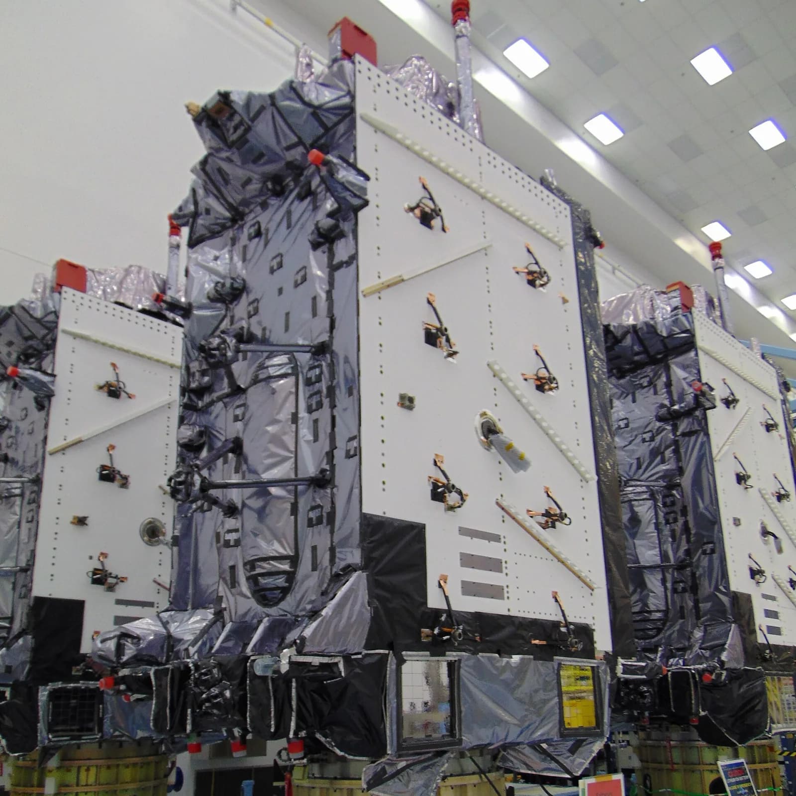
The layout is meant to keep several satellites above the horizon almost anywhere. The orbit is high enough for each satellite to see a large part of the planet, and low enough for the signal to stay strong. The civilian service is free to everyone. The photo shows three GPS III satellites side by side in a clean room, wrapped in silver and black thermal blankets.
A shout with a timestamp
Every satellite carries atomic clocks and broadcasts a radio message that says, in effect: I am satellite number so-and-so, here is my orbit, and at this very instant the time is exactly this. The signals are one-way: your phone does not send anything back. Radio travels at 300,000 km/s, so from a satellite straight overhead, 20,200 km away, the signal needs 20,200 / 300,000 ≈ 0.067 s, about 67 ms.
Your receiver compares the time written in the signal with its own clock. The difference multiplied by the speed of light is the distance to that satellite. Because light is so fast, tiny timing errors become big distances: one microsecond, a millionth of a second, means 300 metres, and to be right within 3 metres a receiver has to measure time to about 10 nanoseconds. That is why the satellites carry atomic clocks, and why ground stations keep correcting them.
Spheres that meet, and the fourth satellite
One satellite says: you are somewhere on a huge sphere around me, with a radius equal to the distance. A second satellite adds another sphere, and the two spheres cut each other in a circle. A third sphere cuts that circle in two points, and one of them lies far out in space, so the Earth’s surface tells you which is real. This method, finding a position from distances alone, is called trilateration. It uses lengths, not angles.
There is a catch. Your phone has no atomic clock, and its own clock may be wrong by a few milliseconds, which would put you hundreds of kilometres off. So the clock error becomes a fourth unknown beside x, y and z, and a fourth satellite is needed to solve for all four. With more satellites in view, the receiver can check the answer and average out the noise.
Einstein rides along
Clocks in orbit tick differently from clocks on the ground, for two reasons. By special relativity the satellite’s speed, about 3.9 km/s, slows its clock by around 7 microseconds a day. By general relativity gravity is weaker at 20,200 km, which speeds the clock up by around 45 microseconds a day. The net gain is about 38 microseconds a day, a result that is described in detail in Neil Ashby’s review in Living Reviews in Relativity.
Left uncorrected, 38 µs × 300,000 km/s is about 11 km of error piling up every day. Engineers therefore set the satellite clocks slightly slow before launch. In that sense, GPS is a daily working test of Einstein’s theories.
Why the dot jumps, and GPS’s neighbours
GPS.gov lists the usual causes of errors: signals blocked by buildings, bridges and trees, indoor or underground use, and signals that bounce off walls and arrive late, called multipath. Many wrong-place cases are mapping errors, not satellite errors. Phones also use Wi-Fi and mobile networks to get a first guess faster, and some newer ones listen on a second civilian frequency. Until 2 May 2000 the United States deliberately degraded the civilian signal, and switching that off made everyday positions far better overnight.
GPS is one of several global navigation satellite systems, GNSS for short. Russia’s GLONASS has 24 or more satellites, Europe’s Galileo declared its first services in 2016, and China’s BeiDou was commissioned in 2020 with about 35 satellites. A modern phone listens to several systems at once, which gives more satellites in view between tall buildings and a backup if one system has a problem.
How the VJOURNAL SMART BOOK shows it
The chapter “GPS and satellite navigation” in the VJOURNAL SMART BOOK “How it works”, Volume I, has five animated moments: satellites sweep around a blue globe, each broadcasts its position and the time, four distances meet at one point, orbiting clocks gain 38 microseconds a day, and other navigation systems join the picture. A 3D model plays the exact moment that the text block describes.
Under the picture is a sandbox. Move the receiver and watch the four signal delays change, then see the position found back from them. The chapter also has key facts, a three-question quiz with explanations and the sources.
In everyday language
Imagine four friends standing far apart, each shouting the exact time. You hear every shout a little late, and the later it arrives, the farther away that friend is. From four delays you can work out where you stand, and also how wrong your own watch is.
Try it yourself
A GPS satellite is 22,000 km from your receiver, and radio travels at 300,000 km/s. How long does its signal take to arrive?
Expected result
22,000 / 300,000 = 0.0733 s, about 73 ms.
Check your answer: Your receiver’s clock runs 3 microseconds fast and nothing corrects it. By about how much is each measured distance wrong?
3 µs × 300,000 km/s = 0.9 km, about 900 m. That is why a fourth satellite is used: it lets the receiver solve for its own clock error.
Questions
How accurate is GPS?
GPS.gov says smartphones are typically accurate to within about 4.9 m under open sky, worse near buildings, bridges and trees. Survey receivers with two frequencies or augmentation systems can reach a few centimetres.
Does GPS need an internet or phone signal?
No. A phone can find its position from satellite signals alone, because the satellites broadcast to everyone. Maps, traffic and search do need data, and phones also use mobile and Wi-Fi networks to get a first fix faster.
How many satellites does a receiver need?
At least four, to solve for the three position coordinates and the receiver’s clock error. In open sky a receiver usually sees many more, which improves the result.
Does GPS track me?
The satellites only broadcast one-way signals and do not know who is listening. Any tracking comes from the apps and networks on your device that choose to record or send the position the receiver has worked out.
Who owns GPS, and is it free?
GPS is owned by the U.S. government and operated by the U.S. Space Force. The civilian service is free to use anywhere in the world.
Why does GPS sometimes show me in the wrong place?
Buildings block or reflect signals, indoor use blocks them, and some errors come from the map software, not the satellites. Occasionally radio interference or solar storms are to blame.
Remember three lines: satellites broadcast the time, a receiver turns delays into distances, and four distances give a position and fix the receiver’s clock. Then open the chapter, move the receiver and watch the delays change.
Sources and further reading
- GPS.gov: The Global Positioning System ↗Sources checked:
- GPS.gov: GPS accuracy ↗Sources checked:
- GPS.gov: Other global navigation satellite systems ↗Sources checked:
- NASA: What is GPS? ↗Sources checked:
- Ashby, Living Reviews in Relativity: Relativity in the Global Positioning System ↗Sources checked: